Last week we used Landsat 7 ETM+ data to examine the vegetated area obscuring the La Danta pyramid and archaeological complex (a Maya site located in Guatemala). Since the location of the complex is known it was used as a control to see if any other areas could be hiding, based on spectral similarities, archaeological structures. First, a new
spectral band combinations (new as last week we looked at a false color and natural color composite) and a normalized difference vegetation index (
NDVI) image were generated. Once these images were generated, I performed a supervised classification to search for probable site locations to survey.
I used the
NDVI tool in the
Image Analysis window to generate the NDVI image. This index is use to determine relative biomass and health of vegetation. Differences in plant growth patterns or in plant health can be used as indicators of the presence of material remains. The NDVI image can help in detecting these differences.
I used the
Composite Band tool again to generate two different band combinations - 7, 5, 4, and 4, 5, 1. The first band combination is ideal for penetrating atmosphere/smoke and highlighting the difference between bare soil and vegetation. The latter band combination is idea in detecting the various stages of plant growth (though precipitation impacts these results). To my eye, the pyramid was still difficult to discern in all of the images. Thankfully, owing to the known location of La Danta a pyramid training sample can be generated and the results can identify areas of similar spectral characteristics. These locations, once refined and examined further, can narrow down the search area for archaeologists.
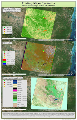 |
| Map deliverable for this module. showing three renderings of a Landsat image. |
The supervised classification was generated with the help of the
Image Classification toolbar in ArcMap. The classes I used were dense forest, forest, water, urban, bare earth, cloud, shadow, and the La Danta area for 'pyramid.' Despite many attempts I was unable to go without multiple classes of the same type. That is, when I combined my training samples (for instance, the two bare earth classes) it introduced greater error in the resulting image. My final classification shows some areas where pyramids could potentially be found. I think, in addition to other contextual visual information, the results could help in determining potential areas to survey.

No comments:
Post a Comment